Cape Crawford Rest Area — Free Camping, Dump Point, Water & Senior Grey Nomad Guide 2026
Cape Crawford Rest Area is a free overnight rest stop in the remote NT–QLD border region of Australia’s outback, located on or near the Carpentaria Highway (Highway 1 alternate / Tablelands Highway junction), approximately 100 km east of Daly Waters and 370 km west of the Queensland border at Camooweal. GPS: -16.6530, 135.7440. It sits in one of the most isolated stretches of highway in Australia, making it an essential transit stop for grey nomads travelling between the Stuart Highway and Queensland via the Savannah Way or Carpentaria Highway. This 2026 guide covers every detail a senior caravan traveller needs — GPS coordinates, facilities, fuel availability, water sources, safety, medical contacts, wildlife warnings, CPAP battery advice, road conditions, and honest assessments from the road. Save GPS: -16.6530, 135.7440 to your Van Life Savings Spots app before you leave Wi-Fi range.
Why Cape Crawford Is the Outback Stop That Separates Prepared Grey Nomads from Stranded Ones
For grey nomads and senior travellers on the Carpentaria Highway, Savannah Way, or the NT to QLD crossing. Includes GPS coordinates, verified facilities, the fuel range calculation that catches unprepared travellers every dry season, CPAP battery planning for multiple unpowered nights, the Lost City rock formations most travellers drive past, remote medical evacuation contacts, and why Cape Crawford is the most important planning checkpoint between the Stuart Highway and Queensland.
- The Remote Highway Stop That Can Make or Break Your NT–QLD Crossing
- Free and Cheap Stops Near Cape Crawford — What Actually Exists
- What You Get at Cape Crawford Rest Area — Honest Facility Breakdown
- Fuel Range: The Calculation That Catches Grey Nomads Every Dry Season
- Dump Point, Water and Toilets — Planning Around Remote Distances
- CPAP Users: Battery Planning for Multiple Unpowered Nights in the Outback
- The Lost City: Cape Crawford’s Hidden Rock Formations
- Wildlife After Dark — Cattle, Kangaroos, Dingoes and Why Night Driving Is Not an Option
- Safety and Security: What Senior Travellers Need to Know in Remote Australia
- Road Conditions: Wet Season Closures, Corrugation, and Rig Suitability
- Accessibility and Mobility: Ground Conditions and Site Layout
- Medical Access: Royal Flying Doctor Service, Nearest Hospitals, and Emergency Contacts
- Mobile Coverage: Satellite Phones, EPIRBs, and Why Your Mobile Will Not Work Here
- Where to Eat, Resupply, and Fuel Before and After Cape Crawford
- GPS, Directions and How to Save This Stop Before You Lose Signal
- Frequently Asked Questions — Cape Crawford Rest Area
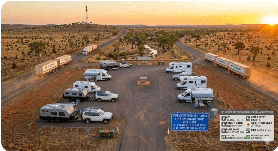
- Your Quick-Reference Card: Cape Crawford at a Glance
1. The Remote Highway Stop That Can Make or Break Your NT–QLD Crossing
Cape Crawford sits at one of the loneliest crossroads in Australia. The Carpentaria Highway runs east from the Stuart Highway at Daly Waters towards Borroloola and the Gulf of Carpentaria. The Tablelands Highway branches south towards Barkly Homestead and the Barkly Highway. Cape Crawford is where these two roads meet — and for grey nomads crossing from the Northern Territory into Queensland via the Savannah Way, or heading south to rejoin the east-west Barkly Highway, this junction is the last point of reliable decision-making before you commit to hundreds of kilometres of remote driving.
This is not the New England Highway. There are no towns every 20 kilometres. There are no roadhouses every 50 kilometres. Between Cape Crawford and the next reliable fuel stop in either direction, you are looking at distances that test fuel tanks, water supplies, and the patience of anyone who has not planned properly. The grey nomads who thrive on this route are the ones who treat Cape Crawford as a critical planning checkpoint — not just another rest area tick on WikiCamps.
Cape Crawford has a roadhouse — the Heartbreak Hotel — which provides fuel, basic supplies, accommodation, and meals. The rest area itself provides a free or low-cost camping option near this junction. For senior travellers, the combination of the roadhouse services and the rest area facilities makes Cape Crawford the single most important logistical stop on the Carpentaria Highway. This article tells you everything you need to plan your stop properly — fuel calculations, water management, CPAP battery planning, medical evacuation contacts, road condition resources, and the remarkable Lost City rock formations that most travellers drive past without knowing they exist.
2. Free and Cheap Stops Near Cape Crawford — What Actually Exists
Options in this region are limited by the sheer remoteness of the landscape. Here is the honest comparison for senior grey nomads deciding where to stop on this section of the Carpentaria Highway and Tablelands Highway.
| Option | Cost | Facilities | Senior Verdict |
|---|---|---|---|
| Daly Waters Pub & Caravan Park | $20–$40/night powered | Powered and unpowered sites. Amenities. Famous pub with meals. Fuel. Water. | Good stop with full services. ~100 km west of Cape Crawford. Iconic pub atmosphere. Fill fuel and water here before heading east. Last full-service stop before Cape Crawford. |
| Cape Crawford Rest Area / Heartbreak Hotel area | Free (rest area) / Low cost (Heartbreak Hotel camping) | Rest area: basic — shade, parking. Heartbreak Hotel: fuel, meals, bar, camping, basic supplies, water. Scenic flights and Lost City tours available. | Critical junction stop. Fuel here — no matter what your gauge says. Water top-up essential. Heartbreak Hotel camping gives you a social evening with fellow travellers. Rest area gives you quiet and free. Either works — but do not skip Cape Crawford entirely. |
| Roadside rest bays — Carpentaria Highway | Free | Bare minimum. Some have shade shelters. No water, no toilets, no facilities at most. | Emergency stops only. Fully self-contained rigs only. No services within 100+ km in either direction from some of these bays. Not recommended as a planned overnight for senior travellers unless you are experienced in remote self-contained camping. |
| Borroloola (north — Gulf of Carpentaria) | $25–$45/night | Caravan park, fuel, basic town services, fishing access. | ~380 km north of Cape Crawford via the Carpentaria Highway. Full day’s drive. Good fishing town but a significant detour if your route is east into QLD. Only relevant if the Gulf is your destination. |
| Barkly Homestead (south then east) | Camping from $15. Fuel available. | Roadhouse, fuel, camping, basic meals and supplies. | ~270 km south of Cape Crawford via the Tablelands Highway. Essential fuel stop if heading south. Confirm fuel availability by phone before departing — remote roadhouses can run out during peak season. |
3. What You Get at Cape Crawford Rest Area — Honest Facility Breakdown
Cape Crawford has two distinct stopping options that grey nomads need to understand clearly: the free rest area near the highway junction, and the Heartbreak Hotel roadhouse which offers paid camping, fuel, meals, and basic supplies. Most grey nomad guides conflate these two — this section separates them so you know exactly what each offers.
Cape Crawford Rest Area (Free)
| Facility | Available? | Senior Notes |
|---|---|---|
| Toilets | ⚠️ Limited — check on arrival | Basic pit toilet may be available at some rest bays in this area. Condition varies seasonally and with maintenance. Carry your own toilet paper, hand sanitiser, and a portable toilet as backup. In remote NT, your van toilet is your primary facility — do not rely on rest area toilets being open, stocked, or clean. |
| Shade | ⚠️ Limited natural shade | Some shade structures or natural tree cover may be present. In the dry season (May–October), temperatures regularly exceed 35°C. Your awning is your primary shade source. Arrive by early afternoon to set up before the hottest part of the day. |
| Parking — caravans and motorhomes | ✅ Yes | Flat, open ground. Room for multiple rigs. Surface is typically red earth and gravel — firm in the dry season, potentially boggy in the wet. Do not drive off formed surfaces after rain. |
| Powered sites | ❌ No | No power. Solar, battery, or generator only. See CPAP section below. In remote outback, your electrical independence is not optional — it is essential. |
| Potable water | ❌ No | No water at the rest area. Fill at the Heartbreak Hotel roadhouse (confirm availability) or carry sufficient water from your last fill point. In this region, carry a minimum of 4 litres per person per day — more in extreme heat. |
| Dump point | ❌ No | No dump point at the rest area. Check with the Heartbreak Hotel for dump point access. Nearest confirmed public dump points may be at Daly Waters (~100 km west) or further. Manage your tanks before arrival. |
| Fuel | ❌ Not at rest area — ✅ at Heartbreak Hotel | Fuel is available at the Heartbreak Hotel roadhouse at Cape Crawford. Fuel here regardless of your tank level. See Section 4 for the critical fuel range calculation. |
| Mobile coverage | ❌ No reliable mobile coverage | No Telstra, Optus or Vodafone mobile coverage at Cape Crawford. You need a satellite phone, satellite messenger (Garmin inReach, Zoleo), or personal locator beacon (PLB/EPIRB) for emergency communication. See Section 13 for full details. |
| Overnight camping | ✅ Yes | Overnight stays permitted for self-contained vehicles. No formal time limit at most remote NT rest areas, but keep your stay reasonable — one to two nights maximum. |
Heartbreak Hotel Roadhouse (Paid — at Cape Crawford)
| Service | Available? | Senior Notes |
|---|---|---|
| Fuel — diesel and unleaded | ✅ Yes | Fill here. Every time. No matter what your gauge reads. Remote fuel pricing applies — expect to pay $2.50–$3.50+ per litre. It is expensive. It is also the only fuel for 100+ km in any direction. The cost of fuel is trivial compared to the cost of being stranded. |
| Meals and bar | ✅ Yes | The Heartbreak Hotel serves meals and has a bar. Classic outback roadhouse atmosphere. After days of cooking in your van, a cooked meal and a cold beer with fellow travellers is one of the genuine pleasures of this route. Check opening hours — they can vary seasonally and close during the wet season. |
| Camping | ✅ Yes — unpowered and possibly powered sites | Camping available at the roadhouse for a fee. Confirm current rates and availability by phone or on arrival — remote roadhouses do not always have online booking systems. Powered sites may be available — confirm before arriving if you rely on power for CPAP or medical equipment. |
| Basic supplies | ✅ Limited | Basic grocery items, cold drinks, ice, and essential supplies. Do not rely on this for your main provisioning — stock up in Katherine, Tennant Creek, or your last major town. Remote roadhouse supplies are emergency-level, not supermarket-level. |
| Water | ✅ Usually available — confirm on arrival | Bore water is typically available at remote roadhouses. It may be drinkable but taste mineral-heavy. Fill your tanks — treat or filter if you prefer. Ask the roadhouse staff about water quality before filling. |
| Accommodation — rooms | ✅ Yes | The Heartbreak Hotel has basic rooms available. For a senior couple who want a bed, a shower, and air conditioning after days of remote camping, a night in a roadhouse room can be a genuine luxury. Confirm rates and availability. |
| Lost City tours and scenic flights | ✅ Yes — bookable through Heartbreak Hotel | The Lost City sandstone formations are one of the NT’s hidden natural wonders. Scenic flights and 4WD tours are bookable through the Heartbreak Hotel. See Section 7 for full details. This alone is worth a two-night stay. |
4. Fuel Range: The Calculation That Catches Grey Nomads Every Dry Season
More grey nomads get into trouble on the Carpentaria Highway through poor fuel planning than any other single factor. The distances between fuel stops in this region are not suggestions — they are hard limits. If your tank does not carry enough fuel for the distance, you do not make the trip. Here is the fuel calculation every grey nomad must do before leaving their last fuel stop.
| Route Segment | Distance | Fuel Needed (at 15L/100km towing) | Notes |
|---|---|---|---|
| Daly Waters → Cape Crawford | ~100 km | ~15 litres | Manageable distance. Fill at Daly Waters before departing. |
| Cape Crawford → Borroloola (north) | ~380 km | ~57 litres | Long stretch. No fuel between. Must fill at Cape Crawford (Heartbreak Hotel). Carry jerry cans as backup. |
| Cape Crawford → Barkly Homestead (south via Tablelands Hwy) | ~270 km | ~41 litres | No fuel between. Road condition varies — corrugation increases fuel consumption. Budget 20% more than calculated. Fill at Cape Crawford. |
| Cape Crawford → Hells Gate Roadhouse (east towards QLD) | ~200+ km | ~30+ litres | Confirm Hells Gate Roadhouse is open and has fuel before departing — remote roadhouses have been known to close temporarily or run out of fuel during peak season. Phone ahead if possible. If Hells Gate is closed, your next fuel is significantly further. |
5. Dump Point, Water and Toilets — Planning Around Remote Distances
In remote outback Australia, the standard grey nomad approach of “I’ll find a dump point in the next town” breaks down completely. There may not be a next town for 300 km. Here is how to manage your three essential needs — toilets, water, and waste — around Cape Crawford.
Toilets
Your onboard van toilet is your primary toilet facility for this entire section of route. Rest area toilets in remote NT may be basic pit-style, poorly maintained, or absent entirely. Carry spare toilet chemicals, spare toilet paper, and know how to empty your cassette or black water tank at a dump point. The Heartbreak Hotel may allow toilet access for customers — ask politely.
Water
Fill your water tanks at every opportunity. The Heartbreak Hotel at Cape Crawford typically has bore water available — confirm on arrival and ask about quality. Carry a minimum of 4 litres of drinking water per person per day in addition to your tank water. In extreme heat (40°C+, which is common in this region from October to March), increase that to 6 litres per person per day. Carry separate emergency water in sealed containers — not in your van tank. If your van tank develops a leak or becomes contaminated, those separate containers are your survival water.
Dump Point
There is no public dump point at Cape Crawford Rest Area. The Heartbreak Hotel may allow dump point access for customers — check on arrival. The nearest confirmed public dump points are likely at Daly Waters (~100 km west) or further afield at Katherine or Tennant Creek. On remote routes, manage your grey water by minimising water use — one-pot cooking, minimal dish washing, sponge baths instead of showers. A grey water tank that lasts three days on the coast may only last two days in remote outback where you are also using more water for drinking and cooling.
6. CPAP Users: Battery Planning for Multiple Unpowered Nights in the Outback
The NT–QLD border region presents the most challenging CPAP battery scenario a grey nomad will face anywhere in Australia. You may go three, four, or even five consecutive nights without access to mains power. A single-night battery plan that works at a rest area near Tamworth is completely inadequate here. This section gives you the multi-night calculation.
| Scenario | Nights Without Power | Battery Capacity Needed (CPAP on DC, no humidifier) | Battery Capacity Needed (CPAP with humidifier via inverter) |
|---|---|---|---|
| 1 night | 1 | ~200 Wh | ~600 Wh |
| 3 nights | 3 | ~600 Wh | ~1800 Wh |
| 5 nights ← realistic on this route | 5 | ~1000 Wh | ~3000 Wh — requires dedicated lithium house battery system |
7. The Lost City: Cape Crawford’s Hidden Rock Formations
Most grey nomads who pass through Cape Crawford treat it as a fuel stop and move on. They drive past one of the Northern Territory’s most remarkable natural features without knowing it exists. The Lost City is a vast landscape of weathered sandstone formations near Cape Crawford that resemble the ruins of an ancient city — towering columns, arches, canyons, and formations that have been sculpted by millions of years of erosion into shapes that look almost deliberately constructed.
The Lost City is not accessible by conventional 2WD vehicle. Access is via 4WD track or scenic helicopter flight, both bookable through the Heartbreak Hotel at Cape Crawford. For senior grey nomads, the scenic flight is the recommended option — it provides spectacular aerial views of the formations without the physical demands of a rough 4WD track, and the flight itself is one of the most memorable experiences available anywhere on the outback touring circuit.
| Lost City Access Option | Duration | Senior Suitability |
|---|---|---|
| Scenic helicopter flight | 30–60 minutes depending on option | Excellent for seniors. No walking required. Air-conditioned. Spectacular views. The formations are best appreciated from the air. Book through the Heartbreak Hotel — flights are weather-dependent and may require a minimum number of passengers. Book early in the dry season when demand is high. |
| 4WD tour | Half day to full day | Rough tracks. Some walking on uneven ground required. Not suitable for seniors with limited mobility, joint issues, or heat sensitivity. Extreme heat in the dry season. Carry at least 3 litres of water per person. Only recommended for fit, experienced travellers comfortable with rough terrain. |
8. Wildlife After Dark — Cattle, Kangaroos, Dingoes and Why Night Driving Is Not an Option
The NT–QLD border region has unfenced pastoral stations spanning thousands of square kilometres. Cattle roam freely across the highway. Kangaroos are abundant. Dingoes hunt at dawn and dusk. Wild horses (brumbies) and donkeys are present on some sections. The wildlife on this route is not a scenic bonus — it is a serious hazard that kills travellers and destroys vehicles every dry season.
| Wildlife | Risk Period | What to Do |
|---|---|---|
| Cattle | 24 hours — but most dangerous at night when they sleep on warm road surfaces | Do not drive at night. Period. A Brahman bull weighing 800 kg lying in the middle of the road at night is invisible until you are on top of it. At 100 km/h, the impact is catastrophic. A bull bar may save your engine — it will not save the passengers. Drive only in daylight. Arrive at your rest area by 3pm. Do not depart before sunrise. |
| Kangaroos | Dawn and dusk — most active 4:30pm–7pm and 5am–7am | Reduce speed to 80 km/h in the last two hours before sunset and the first hour after sunrise. Scan both sides of the road continuously. If you see one kangaroo, expect more — they travel in mobs. |
| Dingoes | Dawn and dusk | Dingoes are generally not a collision risk but can approach camp at night. Secure all food waste. Do not feed dingoes — they become aggressive when habituated to human food. Keep dogs inside or on a short lead at camp — dingoes will attack domestic dogs. |
| Snakes | Warm months — September to April. Active on warm road surfaces at night. | King brown (mulga) snakes and western brown snakes are present in this region. Both are dangerously venomous. Wear closed-toe boots when walking outside your van at any time. Use a torch at night. Do not put your hands under anything without looking first. Carry a pressure immobilisation bandage in your first aid kit. Know snakebite first aid — apply pressure bandage, keep still, call for evacuation. |
| Wild horses and donkeys | Any time — especially near water sources | Brumbies and feral donkeys can appear on the road near creek crossings and bores. They are large, dark-coloured, and extremely difficult to see at dawn/dusk. One more reason to drive only in full daylight on this route. |
9. Safety and Security: What Senior Travellers Need to Know in Remote Australia
Cape Crawford is remote. The safety profile is different from coastal and highway rest areas. Here is the honest assessment for senior grey nomads.
| Safety Factor | Detail | Senior Action |
|---|---|---|
| Isolation | You are 100+ km from the nearest town in any direction. Passing traffic may be sparse — sometimes only a few vehicles per hour. | Carry a satellite communication device (Garmin inReach, Zoleo, satellite phone, or PLB). Register your travel plans with a trusted contact. Check in daily. If you break down, stay with your vehicle — it is visible from the air and provides shade and shelter. Do not walk for help in the outback heat. |
| Heat | Dry season (May–Oct): 30–38°C. Build-up and wet season (Nov–Apr): 35–45°C with extreme humidity. | Drink water constantly — do not wait until you are thirsty. Dehydration in seniors can progress to heat stroke rapidly. Stay in shade during 11am–3pm. If you feel dizzy, nauseous, or stop sweating, this is a medical emergency — pour water on yourself, get into shade, and activate your satellite SOS device. |
| Vehicle breakdown | No roadside assistance coverage in most of this region. RACQ/NRMA/RAA may not attend — check your membership before departure. | Have your vehicle fully serviced before entering remote Australia. Carry spare fan belt, spare radiator hose, tyre repair kit, spare tyre (two if possible), basic tools, and a comprehensive first aid kit. Know how to change a tyre on your rig. If you cannot change a tyre, do not drive remote outback roads. |
| Fellow travellers | During the dry season (May–September), the Carpentaria Highway sees regular grey nomad traffic. October–April, traffic drops significantly. | Travel in the dry season when other travellers are on the road. In the outback, fellow travellers are your first line of assistance. Wave, stop and chat at rest areas, and share road condition reports. The grey nomad community on remote routes is genuinely helpful — a wave down from an oncoming traveller may mean road damage, cattle on the road, or a creek crossing issue ahead. Pay attention. |
10. Road Conditions: Wet Season Closures, Corrugation, and Rig Suitability
Road conditions in the NT–QLD border region vary dramatically between the dry season and the wet season. This section tells you what to expect and how to check conditions before you commit to the route.
| Factor | Dry Season (May–October) | Wet Season (November–April) |
|---|---|---|
| Carpentaria Highway — Daly Waters to Cape Crawford | Sealed. Generally good condition. Some corrugation on shoulders. | May be closed or flooded. Creek crossings can become impassable. Check before travel. |
| Tablelands Highway — Cape Crawford to Barkly Highway | Mix of sealed and unsealed sections. Corrugation can be severe on unsealed sections. Slow down — corrugation at speed damages caravans. | Likely closed. Unsealed sections become impassable in the wet. Do not attempt. |
| Savannah Way east towards QLD | Mix of sealed and unsealed. Road quality varies. Some sections have been upgraded but conditions change year to year. | Closed or severely restricted. Multiple creek crossings become rivers. Do not attempt without local advice and 4WD capability. |
11. Accessibility and Mobility: Ground Conditions and Site Layout
| Factor | Detail | Senior Significance |
|---|---|---|
| Ground surface | Red earth and gravel. Firm in the dry season. Can be soft, sticky, and boggy after any rain. | Wear sturdy closed-toe boots — not thongs, not sandals. Red earth stains everything it touches — be prepared. Uneven ground is common at remote rest areas. Watch your step, especially at dawn and dusk when visibility is lower and snakes may be active. |
| Level parking | Generally flat but not graded like a caravan park. Some natural undulation. | Carry levelling blocks. Assess your position before unhitching — it is easier to reposition than to re-hitch on soft ground. Choose the firmest, flattest area available. |
| Disability accessibility | This is a remote outback rest area. There are no accessibility features — no ramps, no handrails, no sealed paths. | Seniors with significant mobility limitations should assess whether remote outback travel is appropriate for their capabilities. The Heartbreak Hotel may have more accessible facilities — enquire directly. If you use a walking frame or wheelchair, the ground surface at the rest area will be difficult. Consider the Heartbreak Hotel camping or accommodation instead. |
12. Medical Access: Royal Flying Doctor Service, Nearest Hospitals, and Emergency Contacts
This is the most important section of this entire article for senior grey nomads. Cape Crawford has no medical facilities. The nearest hospital is over 250 km away by road. In a medical emergency, your survival may depend on the Royal Flying Doctor Service — and activating them depends on having a working satellite communication device.
| Emergency Service / Hospital | Distance from Cape Crawford | Contact Details |
|---|---|---|
| Royal Flying Doctor Service (RFDS) | Aerial response | Call 000 via satellite phone or activate PLB/EPIRB SOS. The RFDS provides emergency aeromedical evacuation to the nearest hospital. You must have a satellite communication device to reach them from Cape Crawford — there is no mobile coverage. |
| Katherine Hospital | ~400 km west (via Stuart Highway) | Gorge Road, Katherine NT 0850 GPS: -14.4667, 132.2667 Phone: (08) 8973 9211 24-hour emergency department |
| Tennant Creek Hospital | ~450 km south-west (via Tablelands Highway and Stuart Highway) | Schmidt Street, Tennant Creek NT 0860 GPS: -19.6500, 134.1833 Phone: (08) 8962 4399 24-hour emergency department |
| Mount Isa Hospital (QLD) | ~600+ km east | 30 Camooweal Street, Mount Isa QLD 4825 GPS: -20.7264, 139.4930 Phone: (07) 4744 4444 Major regional hospital |
| Emergency — call 000 | — | Via satellite phone or PLB activation. Know your GPS coordinates: -16.6530, 135.7440. Give these to the 000 operator immediately — they enable the RFDS to locate you. |
| Poisons Information Centre | — | 13 11 26 — 24 hours (via satellite phone). For snakebite first aid or poisoning advice. King brown snakes are present in this region and their venom can be fatal without treatment. |
13. Mobile Coverage: Satellite Phones, EPIRBs, and Why Your Mobile Will Not Work Here
| Communication Method | Works at Cape Crawford? | Senior Notes |
|---|---|---|
| Telstra mobile | ❌ No | No Telstra coverage at Cape Crawford. Your phone is a camera and an alarm clock here — not a communication device. |
| Optus mobile | ❌ No | No Optus coverage. |
| Vodafone / TPG | ❌ No | No coverage. |
| Satellite phone (Iridium, Thuraya) | ✅ Yes | Works anywhere on earth with clear sky view. Voice calls and SMS. Rentable from companies like Sat Phone Shop, Pivotel, or RFDS for ~$5–$15/day. Best option for regular communication on remote routes. |
| Satellite messenger (Garmin inReach, Zoleo) | ✅ Yes | Two-way text messaging via satellite. SOS button for emergencies. Tracking feature lets family see your location in real time. Monthly subscription required ($15–$50/month depending on plan). Excellent for daily check-ins with family and emergency SOS. |
| Personal Locator Beacon (PLB/EPIRB) | ✅ Yes | Emergency-only device. Press the SOS button and a distress signal is sent via satellite to AMSA, which coordinates rescue. No two-way communication — it is a one-way emergency alert. No subscription fee. Register at beacons.amsa.gov.au. Minimum recommended device for any remote travel. ~$300–$400 from camping or marine stores. |
| Starlink (satellite internet) | ✅ Yes — if you have the equipment | Starlink roaming plans provide satellite internet in remote areas. Requires a Starlink dish and subscription. Some grey nomads carry Starlink for internet access in remote outback — it works well in this region with clear sky views. Not a replacement for a PLB for emergency use, but provides internet for weather checks, maps, and family contact. |
14. Where to Eat, Resupply, and Fuel Before and After Cape Crawford
| Location | Distance from Cape Crawford | What Is Available |
|---|---|---|
| Heartbreak Hotel — Cape Crawford | At Cape Crawford junction | Fuel (diesel and unleaded), meals, bar, basic supplies, ice, water, camping, rooms, Lost City tours and scenic flights. Open dry season — confirm wet season hours. This is your primary service point at Cape Crawford. |
| Daly Waters — Hi-Way Inn and Pub | ~100 km west | Fuel, iconic pub with meals and entertainment, caravan park, basic supplies. Fill fuel and water here before heading east. The Daly Waters Pub is a legendary outback stop — worth a night in its own right. |
| Hells Gate Roadhouse (east) | ~200+ km east | Fuel, basic meals, camping. Confirm the roadhouse is open and has fuel before departing Cape Crawford — phone ahead via satellite phone if possible, or ask at the Heartbreak Hotel. Remote roadhouses can close temporarily. |
| Barkly Homestead (south) | ~270 km south via Tablelands Hwy | Fuel, camping, basic meals and supplies. Confirm fuel availability before departing Cape Crawford if heading south. |
| Katherine (major town — west) | ~500+ km west via Stuart Highway | Full town services — supermarkets, medical, automotive, caravan supplies. Your last major resupply before Cape Crawford if approaching from the west. Stock up fully in Katherine. |
| Tennant Creek (major town — south-west) | ~450+ km south-west | Full town services. Your last major resupply if approaching from the south via the Stuart Highway. |
15. GPS, Directions and How to Save This Stop Before You Lose Signal
Save Cape Crawford Rest Area and the Heartbreak Hotel to your Vanlife Savings Spots app before you leave your last town with reliable mobile signal. Once you depart Daly Waters heading east, or the Stuart Highway heading south-east, you are entering country with no mobile coverage. Every GPS coordinate, every emergency number, and every piece of route information must be saved on your device before you lose signal.
📍 Save to Vanlife Savings Spots App: Copy the Postcode, Latitude and Longitude below into your Vanlife Savings Spots app to save this stop and get directions.
Cape Crawford Rest Area — Carpentaria Highway / Tablelands Highway Junction, NT
Location: Cape Crawford, Carpentaria Highway, Northern Territory
Postcode: 0852 | Latitude: -16.6530 | Longitude: 135.7440
Cost: Free (rest area) / Low cost (Heartbreak Hotel camping)
Facilities: Basic rest area. Heartbreak Hotel roadhouse nearby — fuel, meals, bar, camping, basic supplies, water, Lost City tours.
⚠️ No mobile coverage — satellite communication device required.
Directions from the west (Stuart Highway / Daly Waters): From Daly Waters on the Stuart Highway, take the Carpentaria Highway east. Cape Crawford is approximately 100 km east of Daly Waters. The Heartbreak Hotel roadhouse is on the highway at the junction with the Tablelands Highway. The road is sealed. Drive only in daylight — cattle on the road.
Directions from the south (Barkly Highway / Barkly Homestead): From Barkly Homestead on the Barkly Highway, take the Tablelands Highway north. Cape Crawford is approximately 270 km north. Road conditions vary — check for corrugation and unsealed sections. Confirm conditions at roadreport.nt.gov.au before departing.
Directions from the east (Savannah Way / QLD border): From Hells Gate Roadhouse or the QLD border region, travel west on the Savannah Way / Carpentaria Highway. Cape Crawford is approximately 200+ km west of Hells Gate. Confirm road conditions before departure — sections may be unsealed.
Katherine Hospital: GPS: -14.4667, 132.2667 | (08) 8973 9211
Tennant Creek Hospital: GPS: -19.6500, 134.1833 | (08) 8962 4399
Mount Isa Hospital (QLD): GPS: -20.7264, 139.4930 | (07) 4744 4444
Emergency: 000 (via satellite phone)
Poisons Info: 13 11 26 (via satellite phone)
AMSA Beacon Registration: beacons.amsa.gov.au
NT Road Conditions: roadreport.nt.gov.au
QLD Road Conditions: qldtraffic.qld.gov.au
Save every one of these to your phone and screenshot this box right now. When you need these numbers, you will not have internet to search for them.
Frequently Asked Questions — Cape Crawford Rest Area
Can you camp overnight at Cape Crawford Rest Area?
Yes — overnight camping is permitted at Cape Crawford Rest Area for self-contained vehicles. There is no formal time limit at most remote NT rest areas, but keep your stay to one or two nights maximum. Alternatively, the Heartbreak Hotel roadhouse at Cape Crawford offers paid camping with access to meals, water, fuel, and the bar. For senior travellers, the Heartbreak Hotel camping is recommended over the basic rest area — the social contact, the cooked meals, and the access to roadhouse services make a significant difference after days of remote driving.
Is there mobile phone coverage at Cape Crawford?
No — there is no Telstra, Optus, or Vodafone mobile coverage at Cape Crawford or along the Carpentaria Highway. You need a satellite communication device for emergency contact — a personal locator beacon (PLB) at minimum, or ideally a satellite messenger (Garmin inReach, Zoleo) or satellite phone. Do not enter this region without a satellite communication device. Your mobile phone will not work here.
Is there fuel at Cape Crawford?
Yes — fuel (diesel and unleaded) is available at the Heartbreak Hotel roadhouse at Cape Crawford. Expect remote pricing — $2.50–$3.50+ per litre. Fill your tank every time you pass a fuel point in this region, regardless of your fuel level. The next fuel stop may be 200–380 km away. Carry a 20-litre jerry can as backup. See Section 4 for the full fuel range calculation.
What is the Lost City at Cape Crawford?
The Lost City is a vast landscape of weathered sandstone formations near Cape Crawford that resemble the ruins of an ancient city — towering columns, arches, and canyons sculpted by millions of years of erosion. It is one of the Northern Territory’s hidden natural wonders. Access is via 4WD track or scenic helicopter flight, both bookable through the Heartbreak Hotel. The helicopter flight is recommended for senior travellers — spectacular views without the physical demands of a rough 4WD track.
Is Cape Crawford safe for senior grey nomads?
Cape Crawford is safe for well-prepared senior grey nomads. The risks on this route are logistical and environmental, not criminal — running out of fuel, dehydration, heat stroke, wildlife strikes, breakdowns in remote areas without communication, and driving at night on unfenced roads with cattle. Every one of these risks is manageable with proper planning. The grey nomads who get into trouble on this route are those who are unprepared. Read this entire guide, follow the fuel, water, and communication advice, and Cape Crawford is a rewarding and memorable outback stop.
What is the best time of year to visit Cape Crawford?
The dry season — May to September — is the only practical time for grey nomads to visit Cape Crawford. Roads are open, conditions are manageable, temperatures are warm but not extreme (25–35°C most days), and the Heartbreak Hotel and its services are operating. The wet season (November to April) brings road closures, flooding, extreme heat (40°C+), dangerous humidity, and many roadhouses close or reduce hours. Do not attempt this route in the wet season with a caravan.
What is the nearest hospital to Cape Crawford?
The nearest hospitals are Katherine Hospital (~400 km west, phone (08) 8973 9211) and Tennant Creek Hospital (~450 km south-west, phone (08) 8962 4399). In a medical emergency, the Royal Flying Doctor Service provides aeromedical evacuation — activated by calling 000 via satellite phone or pressing the SOS button on your PLB or satellite messenger. Know your GPS coordinates (-16.6530, 135.7440) so the rescue team can locate you immediately.
Is Cape Crawford Rest Area pet friendly?
Dogs can be kept at rest areas and at the Heartbreak Hotel camping (confirm with the roadhouse). Keep dogs on lead at all times. Be aware that dingoes are present in this region and will attack domestic dogs — do not let your dog off-lead at any time. Ensure your dog has adequate shade and water in the extreme heat. King brown snakes are present — keep your dog away from long grass, logs, and rock piles.
16. Your Quick-Reference Card: Cape Crawford at a Glance
Save this card before you lose signal. Screenshot it right now. Print it. Put it in your glovebox. Everything you need for Cape Crawford is here — GPS, facilities, fuel stops, hospital contacts, emergency numbers, and the rules that keep you safe in remote Australia.
On your phone — screenshot the table below right now. Opens in Photos with no signal needed.
On a computer — Ctrl+P (Windows) or Cmd+P (Mac) to print. Keep it in the glovebox.
There is no mobile signal at Cape Crawford. If you have not saved this card before you leave Daly Waters, you will not be able to access it when you need it.
| Cape Crawford Rest Area — Senior Quick-Reference Card | |
|---|---|
| Location | Cape Crawford, Carpentaria Highway / Tablelands Highway junction, NT |
| GPS | Latitude: -16.6530 | Longitude: 135.7440 | Postcode: 0852 |
| Cost | Free (rest area). Heartbreak Hotel camping: low cost — confirm on arrival. |
| Heartbreak Hotel Roadhouse | Fuel ✅ | Meals ✅ | Bar ✅ | Camping ✅ | Basic supplies ✅ | Water ✅ | Rooms ✅ | Lost City tours ✅ |
| Rest area facilities | Basic — shade ⚠️ | Parking ✅ | Toilets ⚠️ (check on arrival) |
| NOT available at rest area | Power ❌ | Potable water ❌ | Dump point ❌ | Mobile coverage ❌ |
| ⚠️ MOBILE COVERAGE | NO mobile coverage. Satellite phone, satellite messenger (Garmin inReach/Zoleo), or PLB required. Non-negotiable. |
| Fuel — FILL HERE | Heartbreak Hotel. Diesel + unleaded. $2.50–$3.50+/L. Fill every time. Carry 20L jerry can. Next fuel 100–380 km away. |
| Nearest fuel — west | Daly Waters ~100 km west |
| Nearest fuel — east | Hells Gate Roadhouse ~200+ km east. Confirm open before departing. |
| Nearest fuel — south | Barkly Homestead ~270 km south. Confirm availability. |
| Water | Fill at Heartbreak Hotel (confirm). Carry 4L+ per person per day. Carry emergency water separately from van tank. |
| CPAP users | No power. Need 200Ah+ lithium battery with solar + DC-DC charger for multi-night remote travel. Run CPAP on DC. No humidifier. Use HumidX. Test at home first. See Section 6. |
| Wildlife — CRITICAL | DO NOT DRIVE AT NIGHT. Cattle sleep on road. Kangaroos at dawn/dusk. King brown snakes. Dingoes near camp. Arrive by 3pm. Depart after sunrise. |
| Lost City | Spectacular sandstone formations. Scenic helicopter flight recommended for seniors. Book at Heartbreak Hotel. Worth two nights. |
| Road conditions | Check roadreport.nt.gov.au (NT) and qldtraffic.qld.gov.au (QLD) before every leg. Screenshot results before losing signal. |
| Best time to visit | Dry season only — May to September. Do not attempt in the wet season (Nov–Apr). |
| Nearest hospital — west | Katherine Hospital. ~400 km. GPS: -14.4667, 132.2667. (08) 8973 9211. 24hr ED. |
| Nearest hospital — south-west | Tennant Creek Hospital. ~450 km. GPS: -19.6500, 134.1833. (08) 8962 4399. 24hr ED. |
| Nearest hospital — east (QLD) | Mount Isa Hospital. ~600+ km. GPS: -20.7264, 139.4930. (07) 4744 4444. |
| Emergency | 000 via satellite phone. PLB SOS activation. GPS: -16.6530, 135.7440. Poisons: 13 11 26. |
| Pets | Dogs on lead at all times. Dingoes will attack domestic dogs. Snakes present. Provide shade and water for your dog in extreme heat. |
| Continuing your trip? | Read our best routes to drive around Australia guide before planning your next leg. |
Save the GPS coordinates to your Vanlife Savings Spots app before you leave mobile signal range. In remote outback Australia, the stops you save before losing signal are the only stops you can navigate to with confidence.
GPS: -16.6530, 135.7440 | Postcode: 0852 | Fuel at Heartbreak Hotel | No mobile coverage — satellite device required
― or ―
After days of remote camping, the Heartbreak Hotel at Cape Crawford offers rooms and camping. If you are continuing to Katherine, Tennant Creek, or Mount Isa, search for accommodation at your next major town below.
Accommodation search powered by Expedia. Booking through this search supports this website at no extra cost to you.
Disclaimer: Cape Crawford Rest Area is a remote roadside rest stop in the Northern Territory. The Heartbreak Hotel is a privately operated roadhouse — services, prices, and availability are subject to change without notice, particularly between the dry and wet seasons. GPS coordinates are provided for guidance only — verify in your navigation app and cross-check with paper maps. There are no medical facilities, no mobile phone coverage, and no roadside assistance at Cape Crawford. A satellite communication device is essential for emergency contact. Always call 000 via satellite phone or activate your PLB/EPIRB in a medical emergency. Check road conditions at roadreport.nt.gov.au before every leg of travel. This article is written as an independent guide for grey nomad and senior travellers and is not sponsored by the Heartbreak Hotel, the NT Government, or any government body. All information is current as of the publication date — always confirm conditions on arrival as remote outback services and road conditions can change at any time. Remote Australia is inherently risky — travel prepared, travel in the dry season, and never drive at night.

As an affiliate, I earn from qualifying purchases at no extra cost to you.
As an affiliate, I earn from qualifying purchases at no extra cost to you.